France
Book Hotel
Book Rental Car
Calendars
Cheap Flights
Golf
History
Language
Maps
Music
Places of Interest
Amiens Cathedral
Arc de Triomphe
Champs-Élysées
Citadel of Besançon
Disneyland Paris
Eiffel Tower
Louvre Museum
Notre Dame Cathedral
Palace of Versailles
Promenade des Anglais
Reims Cathedral
More France Attractions
Recipes
Skiing
Towns and Cities
Amiens
Besançon
Bordeaux
Boulogne-Billancourt
Brest
Caen
Dijon
Grenoble
Le Havre
Le Mans
Lille
Lyon
Marseille
Montpellier
Nancy
Nantes
Nice
Orléans
Paris
Reims
Rouen
Saint-Étienne
Strasbourg
Toulon
Toulouse
Tours
More French Cities
Travel Guides
Weather
Links
France Country Information
French Recipes
Learn French Downloads
Learn French eBooks
Travel Downloads
Travel eBooks
Travel Magazines
More Links
| Travel Guide 2 > Europe > France > Towns and Cities > Strasbourg |
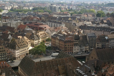
Strasbourg
Strasbourg (German: Straßburg) is the capital and largest city of the Alsace region of France, close to the border with Germany. As of 2004, Strasbourg had an estimated population of 272,800.

Key Facts about Strasbourg
|
- Strasbourg is the capital and largest city of the Alsace region of
France, close to the border with Germany.
- As of
2004,
Strasbourg had an estimated population of 272,800.
- Strasbourg's history dates back to at least Roman times. The Romans
established a military outpost at the city's current location in 12 BCE (or possibly earlier)
and called it Argentoratum.
- During the fall of the Roman Empire, the city was occupied by the Alemanni, Huns, and then Franks.
- The Oaths of Strasbourg (842) marked the division of the Frankish Carolingan Empire
between Charles the Bald, ruler of West Francia, and Louis the German, ruler of East Francia.
This is event is considered by many to be the birth of both France and Germany.
- Strasbourg came under the control of the Holy Roman Empire in 923.
- A number of interesting events took place in Strasbourg during the Middle Ages:
- Construction of Strasbourg Cathedral (French: Cathédrale Notre-Dame de Strasbourg;
German: Liebfrauenmünster zu Straßburg)
began in 1015, although it was only completed in 1439.
As a result of erosion of the
Great Pyramid of Giza in Egypt,
storm damage to Lincoln Cathedral in England,
and fire damage to St. Mary's Church in Stralsund, northern Germany,
it became the tallest building in the world in 1647, a title it held until
over taken by the construction of the
Church of St. Nicholas (German: St.-Nikolai-Kirche)
in Hamburg, Germany.
- In the mid 15th century, Johannes Gutenberg created the
first European moveable type press in Strasbourg.
- In 1518, Strasbourg was struck by the "Dancing Plague of 1518". Numerous people took to dancing continuous without rest, and some died from heart attack, stroke, or exhaustion.
- Construction of Strasbourg Cathedral (French: Cathédrale Notre-Dame de Strasbourg;
German: Liebfrauenmünster zu Straßburg)
began in 1015, although it was only completed in 1439.
As a result of erosion of the
Great Pyramid of Giza in Egypt,
storm damage to Lincoln Cathedral in England,
and fire damage to St. Mary's Church in Stralsund, northern Germany,
it became the tallest building in the world in 1647, a title it held until
over taken by the construction of the
Church of St. Nicholas (German: St.-Nikolai-Kirche)
in Hamburg, Germany.
- During the Thirty Years' War (1618 to 1648), the Free City of Strasbourg
remained neutral. However, the city subsequently attracted the attention
of Louis XIV of France, whose forces occupied the city in 1681.
- During the Franco-Prussian War (1870 to 1871), the city was beseiged and
bombarded by the Prussians, and with the war's conclusion annexed by the
German Empire in 1871.
- With the conclusion of World War I, the city was returned to
France in
1919.
- During World War II, and with the German occupation of France,
Strasbourg was again annexed to Germany during the period from
1940
to 1944.
- After World War II, Strasbourg was chosen as the host city of many European
institutions, starting with the Council of Europe in
1949.
- Today, Strasbourg is the seat of a number of European institutions including:
- The Council of Europe (including the European Court of Human Rights, the European Directorate for the Quality of Medicines, and the European Audiovisual Observatory)
- The Eurocorps,
- The European Parliament
- The European Ombudsman of the European Union
- The Council of Europe (including the European Court of Human Rights, the European Directorate for the Quality of Medicines, and the European Audiovisual Observatory)
- The University of Strasbourg is currently the largest university in France.
- The Strasbourg Grand Mosque (French: La Grande Mosquée de Strasbourg) is the largest Islamic place of worship in France.
Weather in Strasbourg
For current weather information, we recommend: