France
Book Hotel
Book Rental Car
Calendars
Cheap Flights
Golf
History
Language
Maps
Music
Places of Interest
Amiens Cathedral
Arc de Triomphe
Champs-Élysées
Citadel of Besançon
Disneyland Paris
Eiffel Tower
Louvre Museum
Notre Dame Cathedral
Palace of Versailles
Promenade des Anglais
Reims Cathedral
More France Attractions
Recipes
Skiing
Towns and Cities
Amiens
Besançon
Bordeaux
Boulogne-Billancourt
Brest
Caen
Dijon
Grenoble
Le Havre
Le Mans
Lille
Lyon
Marseille
Montpellier
Nancy
Nantes
Nice
Orléans
Paris
Reims
Rouen
Saint-Étienne
Strasbourg
Toulon
Toulouse
Tours
More French Cities
Travel Guides
Weather
Links
France Country Information
French Recipes
Learn French Downloads
Learn French eBooks
Travel Downloads
Travel eBooks
Travel Magazines
More Links
| Travel Guide 2 > Europe > France > Towns and Cities > Grenoble |
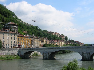
Grenoble
Grenoble is a city in southeastern France, located at the foot of the Alps in the Rhône-Alpes region. As of the 1999 census Grenoble had a population of 514,559, and as of 2007, this figure had risen to an estimated 552,547.
Key Facts about Grenoble
|
- Grenoble is a city in southeastern
France.
- Grenoble is
located at the foot of the Alps in the Rhône-Alpes region.
- As of the
1999 census
Grenoble had a population of 514,559. However, as of
2007,
the population of Grenoble had risen to an estimated 552,547.
- Grenoble is located in the Rhône-Alpes region, and is the capital of the department of Isère.
- Grenoble is sometimes known in France as the "Capital of the Alps".
- Grenoble is an important scientific centre.
- The World Trade Center of Grenoble (WTC G) opened in 1993. As a result of this, Grenoble has become an important international city,
Weather in Grenoble
For current weather information, we recommend: